Difference between revisions of "Mill Wynd"
Jump to navigation
Jump to search
(Added 'See map' reference) |
|||
| Line 1: | Line 1: | ||
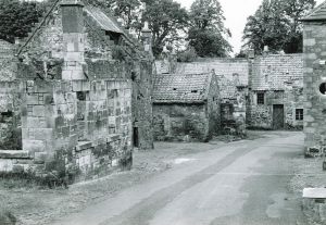
[[File:Mill Wynd, Bruce's Mill.jpg|thumb|Looking down Mill Wynd in the 1960s. Ruins of [[Bruce's Mill]] to the left, an old house straight ahead, both since demolished]]'''Mill Wynd''' is a street in Falkland. It runs from [[Falkland High Street]] to the bridge over the [[Balmblae Burn]]. | [[File:Mill Wynd, Bruce's Mill.jpg|thumb|Looking down Mill Wynd in the 1960s. Ruins of [[Bruce's Mill]] to the left, an old house straight ahead, both since demolished]]'''Mill Wynd''' is a street in Falkland. It runs from [[Falkland High Street]] to the bridge over the [[Balmblae Burn]]. | ||
| + | |||
| + | '''See map''': [[Map D]] (11) | ||
| + | ==Buildings== | ||
The east side of the street contains the following (from north to south): | The east side of the street contains the following (from north to south): | ||
Revision as of 13:48, 30 December 2021

Looking down Mill Wynd in the 1960s. Ruins of Bruce's Mill to the left, an old house straight ahead, both since demolished
Mill Wynd is a street in Falkland. It runs from Falkland High Street to the bridge over the Balmblae Burn.
See map: Map D (11)
Buildings
The east side of the street contains the following (from north to south):
The west side of the street contains the following (from south to north):
(Mill Green, site of the former Bruce's Mill, is here).
In line with Millbank, going west, are:
Higher up, facing Heritage Cottage, is:
Further images
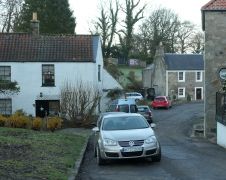
Looking down Mill Wynd in 2021
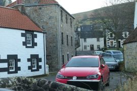
Looking up Mill Wynd in 2021
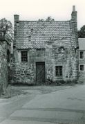
Old house c. 1960s, Bridgend just visible behind.


