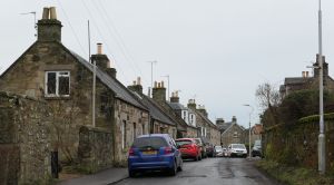
West Port: Difference between revisions
Jump to navigation
Jump to search
No edit summary |
No edit summary |
||
| Line 4: | Line 4: | ||
The entire street, with the exception of Stronvar and Raigmore, is within the [[Falkland Conservation Area]]. | The entire street, with the exception of Stronvar and Raigmore, is within the [[Falkland Conservation Area]]. | ||
'''See map''': [[Map D]] (3) | |||
==Buildings== | |||
From west to east the buildings on the north side are: | From west to east the buildings on the north side are: | ||
Revision as of 13:36, 30 December 2021

West Port is a westward continuation of High Street West. There has been confusion as to which houses are in High Street West and which in West Port.
We have assumed that West Port ends at the junction with Hill Road.
The entire street, with the exception of Stronvar and Raigmore, is within the Falkland Conservation Area.
See map: Map D (3)
Buildings
From west to east the buildings on the north side are:
From west to east the buildings on the south side are:
- Craigmore
- Stronvar
- Rosebank
- Lilacbank
- Lilac Cottage
- Lomond Cottage (entrance in Hill Road)