Difference between revisions of "East Lomond Hill"
| (20 intermediate revisions by 2 users not shown) | |||
| Line 1: | Line 1: | ||
| − | + | {| class="wikitable" style="float:right; width:360px; margin-left:10px;" | |
| − | + | ! colspan="2" | Building summary | |
| − | + | |- | |
| − | + | | colspan="2" style="text-align: center;" | [[File:P1040176a.JPG|340px]] | |
| − | + | |- | |
| − | !HES | + | | style="width:50%"| '''Name''' || East Lomond Hill |
| + | |- | ||
| + | | '''Date''' || Iron Age | ||
| + | |- | ||
| + | | '''See map''' || [[Map B]] | ||
| + | |- | ||
| + | | '''OS grid ref''' || NO 24410 06186 | ||
| + | |- | ||
| + | | '''Latitude & longitude''' || 56°14'32"N 3°13'17"W | ||
| + | |- | ||
| + | | '''what3words''' || [https://what3words.com///reckoned.reward.conductor ///reckoned.reward.conductor] | ||
| + | |- | ||
| + | ! colspan=2 | HES scheduled monument designation details<ref>[http://portal.historicenvironment.scot/designation/SM810 HES record for SM810]</ref> | ||
| + | |- | ||
| + | | '''Reference / Date''' || SM810 / 15/06/1936, updated 16/01/2014 | ||
| + | |- | ||
| + | | '''Address/Site Name''' || East Lomond Hill, fort and cairn | ||
|- | |- | ||
| − | | ''' | + | | colspan=2 | '''Type''' |
| − | + | Crosses and carved stones: symbol stone, Prehistoric domestic and defensive: fort (includes hill fort and promontory fort), Prehistoric ritual and funerary: cairn (type uncertain); cupmarks or cup-and-ring marks and similar rock art | |
|- | |- | ||
| − | | '''Description''' | + | | colspan=2 | '''Description''' |
The monument is the remains of a prehistoric fort and burial cairn on the summit of East Lomond Hill. The hill fort is likely to have been in use in the Iron Age (sometime between 500 BC and AD 600), while the burial cairn is earlier and dates probably from the Bronze Age. The remains of the cairn are visible on the summit as a low, circular turf-covered concentration of stones, measuring around 13m across. [...] | The monument is the remains of a prehistoric fort and burial cairn on the summit of East Lomond Hill. The hill fort is likely to have been in use in the Iron Age (sometime between 500 BC and AD 600), while the burial cairn is earlier and dates probably from the Bronze Age. The remains of the cairn are visible on the summit as a low, circular turf-covered concentration of stones, measuring around 13m across. [...] | ||
|- | |- | ||
| − | |'''Statement of National Importance''' | + | | colspan=2 | '''Statement of National Importance''' |
The monument is of national importance as the upstanding remains of a multi-period site, which includes a prehistoric burial cairn and an Iron Age hill fort with complex defences, which is probably of more than one phase in itself. [...] | The monument is of national importance as the upstanding remains of a multi-period site, which includes a prehistoric burial cairn and an Iron Age hill fort with complex defences, which is probably of more than one phase in itself. [...] | ||
|} | |} | ||
| + | The '''East Lomond Hill''', also known as '''Falkland Hill''' (height 448 metres) dominates the town of Falkland from the south. | ||
| + | It contains a scheduled monument '''East Lomond Hill, fort and cairn''' (HES reference SM810). | ||
==Further references== | ==Further references== | ||
| − | "A multivallate Iron Age | + | "A multivallate Iron Age hillfort, the highest in Fife (424m. O.D.) on a commanding site, measuring 60m. by 30m, within as many as four walls or ramparts. [...]"<ref>[[Gifford, Fife|Gifford, ''Fife'']], page 203.</ref> |
==Notes== | ==Notes== | ||
<references /> | <references /> | ||
| + | |||
| + | ==Further images== | ||
| + | <gallery mode=packed style="text-align:left"> | ||
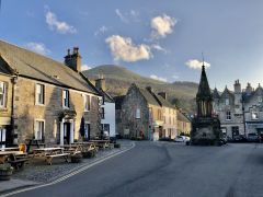
| + | File:50289397736 fa5fbab5e8 o.jpg|[[Falkland High Street]] and the hill | ||
| + | </gallery> | ||
| + | |||
[[Category:Scheduled monuments]] | [[Category:Scheduled monuments]] | ||
[[Category:Natural features]] | [[Category:Natural features]] | ||
[[Category:Outlying areas]] | [[Category:Outlying areas]] | ||
Latest revision as of 21:27, 8 February 2024
| Building summary | |
|---|---|

| |
| Name | East Lomond Hill |
| Date | Iron Age |
| See map | Map B |
| OS grid ref | NO 24410 06186 |
| Latitude & longitude | 56°14'32"N 3°13'17"W |
| what3words | ///reckoned.reward.conductor |
| HES scheduled monument designation details[1] | |
| Reference / Date | SM810 / 15/06/1936, updated 16/01/2014 |
| Address/Site Name | East Lomond Hill, fort and cairn |
| Type
Crosses and carved stones: symbol stone, Prehistoric domestic and defensive: fort (includes hill fort and promontory fort), Prehistoric ritual and funerary: cairn (type uncertain); cupmarks or cup-and-ring marks and similar rock art | |
| Description
The monument is the remains of a prehistoric fort and burial cairn on the summit of East Lomond Hill. The hill fort is likely to have been in use in the Iron Age (sometime between 500 BC and AD 600), while the burial cairn is earlier and dates probably from the Bronze Age. The remains of the cairn are visible on the summit as a low, circular turf-covered concentration of stones, measuring around 13m across. [...] | |
| Statement of National Importance
The monument is of national importance as the upstanding remains of a multi-period site, which includes a prehistoric burial cairn and an Iron Age hill fort with complex defences, which is probably of more than one phase in itself. [...] | |
The East Lomond Hill, also known as Falkland Hill (height 448 metres) dominates the town of Falkland from the south. It contains a scheduled monument East Lomond Hill, fort and cairn (HES reference SM810).
Further references
"A multivallate Iron Age hillfort, the highest in Fife (424m. O.D.) on a commanding site, measuring 60m. by 30m, within as many as four walls or ramparts. [...]"[2]
Notes
- ↑ HES record for SM810
- ↑ Gifford, Fife, page 203.
Further images
Falkland High Street and the hill
