Difference between revisions of "Sharps Close"
Jump to navigation
Jump to search
| (9 intermediate revisions by 2 users not shown) | |||
| Line 1: | Line 1: | ||
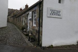
| − | [[File: | + | [[File:Sharps Close.JPG|thumb|[[Cottage Craft Centre]] and Sharps Close]]'''Sharps Close''' is a narrow lane running south from [[Brunton Street]] to [[Back Dykes]]. |
| + | '''See map:''' [[Map T]] (16) | ||
| + | |||
| + | '''what3words''' [https://what3words.com/visions.pose.breakfast ///visions.pose.breakfast] (junction wiht Brunton Street) | ||
| + | ==Buildings== | ||
The East side of the Close is largely occupied by the outbuildings of [[Wester Brunton]]. Buildings in Sharps Close itself are: | The East side of the Close is largely occupied by the outbuildings of [[Wester Brunton]]. Buildings in Sharps Close itself are: | ||
*[[Cottage Craft Centre]] | *[[Cottage Craft Centre]] | ||
| Line 6: | Line 10: | ||
*[[Sweetheart Cottage]] | *[[Sweetheart Cottage]] | ||
| − | [[ | + | ==Further images== |
| − | [[Category: | + | <gallery mode=packed> |
| + | File:Wester Brunton gable.JPG|Sharps Close and gable end of [[Wester Brunton]] | ||
| + | </gallery> | ||
| + | |||
| + | [[Category:Streets and roads]] | ||
[[Category:Royal Burgh of Falkland]] | [[Category:Royal Burgh of Falkland]] | ||
[[Category:Falkland Conservation Area]] | [[Category:Falkland Conservation Area]] | ||
Latest revision as of 17:15, 8 February 2024

Cottage Craft Centre and Sharps Close
Sharps Close is a narrow lane running south from Brunton Street to Back Dykes.
See map: Map T (16)
what3words ///visions.pose.breakfast (junction wiht Brunton Street)
Buildings
The East side of the Close is largely occupied by the outbuildings of Wester Brunton. Buildings in Sharps Close itself are:
Further images
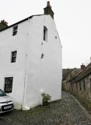
Sharps Close and gable end of Wester Brunton
