Old Free Church: Difference between revisions
No edit summary |
No edit summary |
||
| (22 intermediate revisions by 2 users not shown) | |||
| Line 1: | Line 1: | ||
{| class="wikitable" style="float:right; | {| class="wikitable" style="float:right; width:360px; margin-left:10px;" | ||
! colspan="2" | Building summary | |||
! colspan="2"|Building | |||
|- | |- | ||
| colspan="2"| [[File:Old Free Church.jpg| | | colspan="2" style="text-align: center; font-style: italic;"| [[File:Old Free Church 2024.jpg|340px]] | ||
|- | |- | ||
| style="width:50%" |'''Name'''|| Old Free Church | | style="width:50%" |'''Name'''|| Old Free Church | ||
| Line 11: | Line 10: | ||
| '''Postcode'''|| KY15 7AN | | '''Postcode'''|| KY15 7AN | ||
|- | |- | ||
| '''Other names'''|| United Free Church | | rowspan="2" | '''Other names'''|| United Free Church | ||
|- | |||
| Parish Church Hall | |||
|- | |- | ||
| '''Date'''|| 1844 | | '''Date'''|| 1844 | ||
|- | |- | ||
| '''OS grid ref'''|| | | '''See map''' || [[Map D]] (36) | ||
|- | |||
| '''OS grid ref'''|| NO 25476 07469 | |||
|- | |- | ||
| '''Latitude & longitude'''|| 56°15'13"N 3°12'15"W | | '''Latitude & longitude'''|| 56°15'13"N 3°12'15"W | ||
|- | |- | ||
| ''' | | '''what3words''' || [https://what3words.com///enormous.cubed.period ///enormous.cubed.period] | ||
|- | |- | ||
| ''' | ! colspan=2 | HES listing details<ref>[http://portal.historicenvironment.scot/designation/LB31293 HES record for LB31293]</ref> | ||
|- | |- | ||
| ''' | | '''Category''' || B | ||
|- | |||
| '''Reference / Date''' || LB31293 / 12/01/1971 | |||
|- | |||
| '''Address/Site Name''' || Parish Church Hall, New Road | |||
|- | |||
| colspan=2 | '''Description:''' | |||
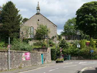
Dated 1844, originally Free Church. Plain gothic rectangle coursed rubble, 2-window gable front with Y-tracery and bellcote, small single-storey south verstry & c. wing. | |||
|- | |||
| colspan=2| '''Statement of special interest:''' | |||
Elevated site, prominent position overlooking East Port. | |||
|- | |||
! colspan=2 | 1963 listing details<ref>[[List of buildings, 1963]].</ref> | |||
|- | |||
| '''Number:''' || 69 | |||
|- | |||
| '''Address/Site Name''' || Parish Church Hall, East Port | |||
|- | |||
| colspan=2 | '''Description:''' | |||
Dated 1844: oblong with Gothic belfry: coursed rubble and slate: elevated·site: originally Free Church | |||
|} | |} | ||
__NOTOC__ | __NOTOC__ | ||
'''Old Free Church''' is a former place of worship (United Free Church) in [[Pleasance]] / [[New Road]], Falkland, now converted to a private house. | '''Old Free Church''' is a former place of worship (United Free Church) in [[Pleasance]] / [[New Road]], Falkland, now converted to a private house. | ||
In the 1843 ‘Disruption’ many ministers and congregations broke away from the "Established" Church of Scotland to form the Free Church of Scotland. Falkland’s Free Church was built the very next year in an elevated position facing down the High Street. In 1929 what had become the United Free Church was reunited with the Church of Scotland, and there was no longer a need for two church buildings in Falkland. The former Free Church was used for a time as a church hall, but has now been converted for use as a private residence. | |||
==Previous uses== | ==Previous uses== | ||
Place of worship (United Free Church), later a community hall from (?) 1975 to early 2000s.<ref name="occ">Information from occupier.</ref> | Place of worship (United Free Church), later a community hall from (?) 1975 to early 2000s.<ref name="occ">Information from occupier.</ref> | ||
| Line 45: | Line 66: | ||
==Notes== | ==Notes== | ||
<references /> | <references /> | ||
== | ==Further images== | ||
<gallery mode=packed> | <gallery mode=packed> | ||
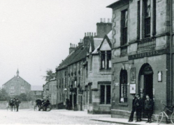
File:Town Hall and U.F.Church.png|The church in the early 20th century at the end of the High Street (Town Hall on right) | File:Town Hall and U.F.Church.png|The church in the early 20th century at the end of the High Street (Town Hall on right) | ||
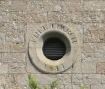
File:FreeChurchPlaque.JPG|Circular feature inscribed "FREE CHURCH 1844" | |||
</gallery> | </gallery> | ||
[[Category:Category B listed buildings]] | |||
[[Category:Falkland Conservation Area]] | |||
Latest revision as of 09:50, 4 June 2024
| Building summary | |
|---|---|

| |
| Name | Old Free Church |
| Address | Pleasance (or New Road), Falkland |
| Postcode | KY15 7AN |
| Other names | United Free Church |
| Parish Church Hall | |
| Date | 1844 |
| See map | Map D (36) |
| OS grid ref | NO 25476 07469 |
| Latitude & longitude | 56°15'13"N 3°12'15"W |
| what3words | ///enormous.cubed.period |
| HES listing details[1] | |
| Category | B |
| Reference / Date | LB31293 / 12/01/1971 |
| Address/Site Name | Parish Church Hall, New Road |
| Description:
Dated 1844, originally Free Church. Plain gothic rectangle coursed rubble, 2-window gable front with Y-tracery and bellcote, small single-storey south verstry & c. wing. | |
| Statement of special interest:
Elevated site, prominent position overlooking East Port. | |
| 1963 listing details[2] | |
| Number: | 69 |
| Address/Site Name | Parish Church Hall, East Port |
| Description:
Dated 1844: oblong with Gothic belfry: coursed rubble and slate: elevated·site: originally Free Church | |
Old Free Church is a former place of worship (United Free Church) in Pleasance / New Road, Falkland, now converted to a private house.
In the 1843 ‘Disruption’ many ministers and congregations broke away from the "Established" Church of Scotland to form the Free Church of Scotland. Falkland’s Free Church was built the very next year in an elevated position facing down the High Street. In 1929 what had become the United Free Church was reunited with the Church of Scotland, and there was no longer a need for two church buildings in Falkland. The former Free Church was used for a time as a church hall, but has now been converted for use as a private residence.
Previous uses
Place of worship (United Free Church), later a community hall from (?) 1975 to early 2000s.[3]
Extensions
Renovated early 2000s ?[3]
Further references
Prominently sited simple Gothic box built in 1844–5. Small spired bellcote with gableted openings.[4]
Notes
- ↑ HES record for LB31293
- ↑ List of buildings, 1963.
- ↑ 3.0 3.1 Information from occupier.
- ↑ Gifford, Fife page 218.
Further images
-
The church in the early 20th century at the end of the High Street (Town Hall on right)
-
Circular feature inscribed "FREE CHURCH 1844"

