Bridgend: Difference between revisions
Jump to navigation
Jump to search
No edit summary |
No edit summary |
||
| Line 16: | Line 16: | ||
| '''Latitude & longitude''' || 56°15′13″N 3°12′33″W | | '''Latitude & longitude''' || 56°15′13″N 3°12′33″W | ||
|- | |- | ||
|} | |} | ||
__NOTOC__ | __NOTOC__ | ||
| Line 26: | Line 23: | ||
! colspan=3 | HES listing details<ref>[http://portal.historicenvironment.scot/designation/LB8804 HES record for LB8804]</ref> | ! colspan=3 | HES listing details<ref>[http://portal.historicenvironment.scot/designation/LB8804 HES record for LB8804]</ref> | ||
|- | |- | ||
| '''Reference:''' | | '''Reference:''' LB8804 | ||
| '''Date:''' | | '''Date:''' 01/02/1972 | ||
| '''Category:''' | | '''Category:''' B | ||
|- | |- | ||
| colspan=3 | '''Address/Site Name''' | | colspan=3 | '''Address/Site Name''' | ||
Revision as of 18:28, 1 April 2021
| Building summary | |
|---|---|

| |
| Name | Bridgend |
| Address | Balmblae, Falkland |
| Postcode | KY15 7BS |
| Date | 18th century |
| OS grid ref | NO 25185 7444 |
| Latitude & longitude | 56°15′13″N 3°12′33″W |
Bridgend is a house in Balmblae Falkland.
| HES listing details[1] | ||
|---|---|---|
| Reference: LB8804 | Date: 01/02/1972 | Category: B |
| Address/Site Name
Bridgend, East End, Balmblae, Falkland | ||
| Description
18th century, former public house, 2-storey 3-window rubble-built with margins and moulded eaves course, gables harled; slated, crowstepped at back. | ||
Previous uses
Public house.
Notes
Gallery
[Click on a picture below to see the image full-size]
-
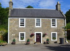 The house
 -
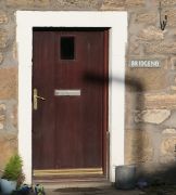 Front door and house name
