Community Council area: Difference between revisions
Jump to navigation
Jump to search
Created page with "thumb|The red outline shows the Community Council area, compared to the light brown shading representing the old Parish of FalklandThe '''Royal Burgh of Fa..." |
No edit summary |
||
| Line 1: | Line 1: | ||
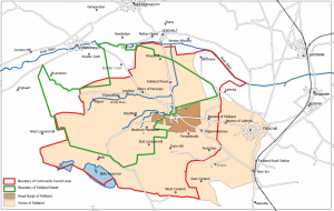
[[File:Map B+.png|thumb|The red outline shows the Community Council area, compared to the light brown shading representing the old Parish of Falkland]]The '''Royal Burgh of Falkland and Newton of Falkland Community Council''' met for the first time in 1978 | [[File:Map B+.png|thumb|The red outline shows the Community Council area, compared to the light brown shading representing the old Parish of Falkland]]The '''Royal Burgh of Falkland and Newton of Falkland Community Council''' met for the first time in 1978. | ||
It covers an area that partly corresponds to the old [[Parish of Falkland]] but excluding [[Freuchie]] and including an area around [[Nochnarie]] to the north of [[Lathrisk]] (which itself is still not included). | |||
[[Category:Community Council]] | [[Category:Community Council]] | ||
Latest revision as of 10:04, 4 January 2022

The Royal Burgh of Falkland and Newton of Falkland Community Council met for the first time in 1978.
It covers an area that partly corresponds to the old Parish of Falkland but excluding Freuchie and including an area around Nochnarie to the north of Lathrisk (which itself is still not included).