Back Wynd: Difference between revisions
Jump to navigation
Jump to search
No edit summary |
No edit summary |
||
| (9 intermediate revisions by the same user not shown) | |||
| Line 1: | Line 1: | ||
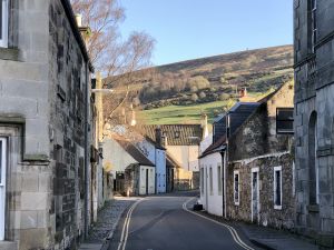
[[File:50289580822 353b533720 o.jpg|thumb|Back Wynd and the East Lomond Hill]]'''Back Wynd''' runs between [[High Street]] and [[Horsemarket]] / [[South Street]]. | [[File:50289580822 353b533720 o.jpg|thumb|Back Wynd and the East Lomond Hill]]'''Back Wynd''' runs between [[High Street]] and [[Horsemarket]] / [[South Street]]. It continues south as [[Wellbrae]]. | ||
'''See map:''' [[Map D]] (51) | |||
'''what3words:''' [https://what3words.com/dressings.flanked.prettiest ///dressings.flanked.prettiest] | |||
==Buildings== | |||
The western side of Back Wynd contain the following, from south to north: | The western side of Back Wynd contain the following, from south to north: | ||
*[[Lomond Pharmacy]] | *[[Former Lomond Pharmacy]] | ||
*[[Keppoch]] | *[[Keppoch]] | ||
*[[Rosemary Cottage]] | *[[Rosemary Cottage]] | ||
*[[Hayloft Tearoom]] | *[[Hayloft Tearoom]] | ||
*[[The Old Stables]] | |||
*[[Dunira]] | *[[Dunira]] | ||
The eastern side contains the following, from south to north: | The eastern side contains the following, from south to north: | ||
*[[Southbank]] | *[[Southbank]] (address in [[Horsemarket]]). | ||
*[[The Cottage (Pedder)]] - behind The Haven | *[[The Cottage (Pedder)]] - behind The Haven | ||
*[[The Haven]] | *[[The Haven]] | ||
| Line 22: | Line 28: | ||
An alleyway between [[The Weaving House]] and [[Crinan]] leads past [[Bank Cottage]] to [[Falconlea]] and then the car park. | An alleyway between [[The Weaving House]] and [[Crinan]] leads past [[Bank Cottage]] to [[Falconlea]] and then the car park. | ||
An extension to Back Wynd (between Smart Cookies and The Haven) leads to the [[Falkland Community Hall]] and the [[Sugar Acre Gardens]]. | An extension to Back Wynd (between Smart Cookies and The Haven) leads past [[Briar Cottage]] to the [[Falkland Community Hall]] and the [[Sugar Acre Gardens]]. | ||
==Further images== | ==Further images== | ||
Latest revision as of 09:49, 20 March 2024

Back Wynd runs between High Street and Horsemarket / South Street. It continues south as Wellbrae.
See map: Map D (51)
what3words: ///dressings.flanked.prettiest
Buildings
The western side of Back Wynd contain the following, from south to north:
The eastern side contains the following, from south to north:
- Southbank (address in Horsemarket).
- The Cottage (Pedder) - behind The Haven
- The Haven
- Smart Cookies Nursery
- Hillview
- The Cottage (Stebbings)
- Crinan
- The Weaving House
An alleyway between The Weaving House and Crinan leads past Bank Cottage to Falconlea and then the car park.
An extension to Back Wynd (between Smart Cookies and The Haven) leads past Briar Cottage to the Falkland Community Hall and the Sugar Acre Gardens.
Further images
-
Looking north to the High Street and Maspie House
