Falkland Conservation Area: Difference between revisions
Jump to navigation
Jump to search
No edit summary |
No edit summary |
||
| Line 1: | Line 1: | ||
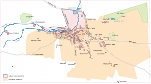
[[File:Map | [[File:Map C+.png|thumb|The former [[Royal Burgh of Falkland]],and the current Conservation Area. Based on [[Playfair and Burgess]], Map C. Roads and buildings as at around 1910. Click on the map to see a larger version.]]The '''Falkland Conservation Area''' was the first such area in Scotland to be so designated, in 1970.<ref>[http://publications.fifedirect.org.uk/c64_Falkland-final.pdf Falkland Conservation Area Appraisal and Management Plan] (ARC Architects for Fife Council, 2010).</ref> | ||
==Notes== | ==Notes== | ||
Latest revision as of 17:09, 22 December 2021

The Falkland Conservation Area was the first such area in Scotland to be so designated, in 1970.[1]
Notes
- ↑ Falkland Conservation Area Appraisal and Management Plan (ARC Architects for Fife Council, 2010).