Campbell's Café: Difference between revisions
Jump to navigation
Jump to search
No edit summary |
No edit summary |
||
| Line 21: | Line 21: | ||
|- | |- | ||
| '''Latitude & longitude''' || 56°15′11″N 3°12′30″W | | '''Latitude & longitude''' || 56°15′11″N 3°12′30″W | ||
|- | |||
! colspan=2 | HES listing details<ref>[http://portal.historicenvironment.scot/designation/#### HES record for ####]</ref> | |||
|- | |||
| '''Category:''' || | |||
|- | |||
| '''Reference / date''' || | |||
|- | |||
| '''Address/Site Name''' || | |||
|- | |||
| colspan=2 | '''Description''' | |||
|- | |||
| colspan=2| '''Statement of special interest''' | |||
|- | |||
! colspan=2 | 1963 listing details<ref>[[List of buildings, 1963]].</ref> | |||
|- | |||
| '''Number:''' || | |||
|- | |||
| '''Address/Site Name''' || | |||
|- | |||
| colspan=2 | '''Description''' | |||
|} | |} | ||
__NOTOC__ | __NOTOC__ | ||
Revision as of 09:02, 23 January 2024
| Building summary | |
|---|---|

| |
| Name | Campbell's Café |
| Address | High Street, Falkland |
| Postcode | KY15 7BU |
| Other names | Falkland Equitable Co-operative Society |
| Warbecks Restaurant | |
| Date | 1886 |
| See map | Map D (17) |
| OS grid ref | NO 25224 07378 |
| Latitude & longitude | 56°15′11″N 3°12′30″W |
| HES listing details[1] | |
| Category: | |
| Reference / date | |
| Address/Site Name | |
| Description | |
| Statement of special interest | |
| 1963 listing details[2] | |
| Number: | |
| Address/Site Name | |
| Description | |
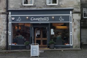
Campbell's Café occupies the right-hand part of the building known as the Old Town House in Falkland High Street. It was previously called "Warbecks",[3] and the accommodation above the café is known as Warbeck House.
| HES listing details[4] | ||
|---|---|---|
| Reference: LB31261 | Date: 01/12/1971 | Category: C |
| Address/Site Name
Savings Bank and Co-operative Building, High Street | ||
| Description
See Old Town House | ||
Previous uses
- Grocery
- Restaurant
- Pharmacy
Notes
- ↑ HES record for ####
- ↑ List of buildings, 1963.
- ↑ Google Streetview shows it as "Warbecks" in October 2009.
- ↑ HES record for LB31261. Covers the entire building, including the Violin Shop and Warbeck House.