Difference between revisions of "Falkland Conservation Area"
Jump to navigation
Jump to search
| (One intermediate revision by one other user not shown) | |||
| Line 1: | Line 1: | ||
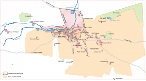
| − | [[File:Map | + | [[File:Map C+.png|thumb|The former [[Royal Burgh of Falkland]],and the current Conservation Area. Based on [[Playfair and Burgess]], Map C. Roads and buildings as at around 1910. Click on the map to see a larger version.]]The '''Falkland Conservation Area''' was the first such area in Scotland to be so designated, in 1970.<ref>[http://publications.fifedirect.org.uk/c64_Falkland-final.pdf Falkland Conservation Area Appraisal and Management Plan] (ARC Architects for Fife Council, 2010).</ref> |
==Notes== | ==Notes== | ||
<references /> | <references /> | ||
[[Category:Falkland Conservation Area| ]] | [[Category:Falkland Conservation Area| ]] | ||
| + | [[Category:Articles with maps]] | ||
Latest revision as of 17:09, 22 December 2021

The former Royal Burgh of Falkland,and the current Conservation Area. Based on Playfair and Burgess, Map C. Roads and buildings as at around 1910. Click on the map to see a larger version.
The Falkland Conservation Area was the first such area in Scotland to be so designated, in 1970.[1]
Notes
- ↑ Falkland Conservation Area Appraisal and Management Plan (ARC Architects for Fife Council, 2010).