Difference between revisions of "Mill Wynd Bridge"
Jump to navigation
Jump to search
| Line 16: | Line 16: | ||
| '''Latitude & longitude''' || 56°15′12″N 3°12′32″W | | '''Latitude & longitude''' || 56°15′12″N 3°12′32″W | ||
|- | |- | ||
| − | | '''what3words''' || | + | | '''what3words''' || [https://what3words.com///threading.rooster.absent ///threading.rooster.absent] |
|- | |- | ||
! colspan=2 | HES listing details<ref>[http://portal.historicenvironment.scot/designation/LB31340 HES record for LB31340]</ref> | ! colspan=2 | HES listing details<ref>[http://portal.historicenvironment.scot/designation/LB31340 HES record for LB31340]</ref> | ||
Latest revision as of 16:47, 8 February 2024
| Building summary | |
|---|---|
 View from Balmblae View from Balmblae
| |
| Name | Mill Wynd Bridge |
| Address | ? |
| Postcode | ? |
| Date | Early 19th century ? |
| OS grid ref | NO 25193 7426 |
| Latitude & longitude | 56°15′12″N 3°12′32″W |
| what3words | ///threading.rooster.absent |
| HES listing details[1] | |
| Category: | C |
| Reference / date | LB31340 / 12/01/1971 |
| Address/Site Name | Mill Wynd Bridge, over Maspie Burn |
| Description
Probably rebuilt early 19 century small single segmental arch, rubble-built. | |
| Statement of special interest
Partly in Falkland landward parish. Re-categorised as C(S) from B for Group (2006). | |
| 1963 listing details[2] | |
| Number: | 62 |
| Address/Site Name | Mill Wynd Bridge over Maspie Burn |
| Description
Small single segmental arch: rubble: probably rebuilt early 19th Century | |
The Mill Wynd Bridge is a bridge across the Maspie Burn, leading from Mill Wynd in the former Royal Burgh to Balmblae, which was outside the Royal Burgh and therefore in the landward part of the Parish of Falkland.
Further references
Notes
Further images
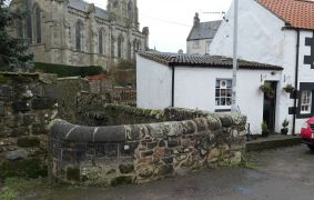
Looking towards the church and Stag Inn
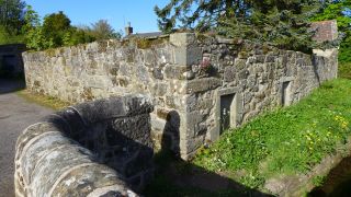
Ruined cottage next to the bridge

