Difference between revisions of "Cross Wynd"
| (One intermediate revision by the same user not shown) | |||
| Line 5: | Line 5: | ||
'''See map:''' [[Map T]] (14); [[Map D]] (54) | '''See map:''' [[Map T]] (14); [[Map D]] (54) | ||
| + | |||
| + | '''what3words:''' [https://what3words.com/skis.prospers.bolsters ///skis.prospers.bolsters] | ||
==East side== | ==East side== | ||
| Line 25: | Line 27: | ||
==West side== | ==West side== | ||
*[[Post Office (Cross Wynd)]] - since burnt down | *[[Post Office (Cross Wynd)]] - since burnt down | ||
| − | *[[ | + | *[[Former houses in Cross Wynd]] - now demolished |
==Further references== | ==Further references== | ||
Latest revision as of 17:22, 8 February 2024

Cross Wynd runs from north to south, at right angles to the High Street, It starts at High Street, continues to a cross-roads separating Brunton Street and Horsemarket and ends at Back Dykes.
Much of the west side of Cross Wynd was demolished to form Brunton Green and a car park.
Until the drainage works in 1901, a burn ran down the centre of the Wynd, bringing yellow sand from the hill. Housewives would bring their pots and pans here to wash and scour them.[1]
See map: Map T (14); Map D (54)
what3words: ///skis.prospers.bolsters
East side
From north to south, the houses on the east side are:
- Seton House
- The Corrie (incorporating Bonnie Boo Kids)
- Cobblestones
- "House (Mrs Lilias Chisholm), Cross Wynd" (not identified)
- The Wynd
- Wynd Cottage (1 Parliament Square)
- 2 Parliament Square
- The Smiddy (3 Parliament Square
- The Shien (4 Parliament Square)
- Cross Wynd Cottage
(Horsemarket is here)
- Thistle Cottage (round the corner)
- Ivy Cottage
- Arthur Place
- Ashgrove Cottage
West side
- Post Office (Cross Wynd) - since burnt down
- Former houses in Cross Wynd - now demolished
Further references
"In Cross Wynd ... harled C17 and C18 houses, one [The Corrie] with a round-headed blind window in the chimney gablet, another [The Corrie (southern extension)] dated 1686 and a third [Cobblestones] dated 1764."[2]
Notes
- ↑ A Falkland Guide, page 9.
- ↑ Gifford, Fife, page 220.
Further images
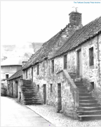
Houses on the west side, 1954 prior to demolition
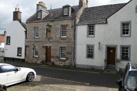
Northern end of Cross Wynd
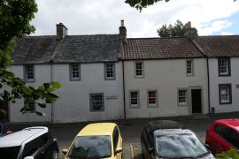
Another view
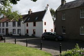
Another view


