Difference between revisions of "Horsemarket"
Jump to navigation
Jump to search
| Line 1: | Line 1: | ||
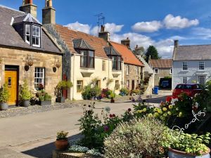
[[File:50312135033 86a8a6fd7a o(2).jpg|thumb|Horsemarket]]'''Horsemarket''', also known as '''Horsemarket Street''', is part of the secondary east-axis of Falkland. | [[File:50312135033 86a8a6fd7a o(2).jpg|thumb|Horsemarket]]'''Horsemarket''', also known as '''Horsemarket Street''', is part of the secondary east-axis of Falkland. | ||
| − | It runs between [[Back Wynd]] and [[Cross Wynd]] | + | It runs between [[Back Wynd]] and [[Cross Wynd]]. |
| + | |||
| + | '''See map:''' [[Map D]] (52) | ||
| + | |||
| + | ==Buildings== | ||
[[Southbank]] has a Horsemarket address, and faces down Horsemarket, but continues the line of buildings on the east side of [[Back Wynd]]. | [[Southbank]] has a Horsemarket address, and faces down Horsemarket, but continues the line of buildings on the east side of [[Back Wynd]]. | ||
Revision as of 17:02, 2 January 2022
Horsemarket, also known as Horsemarket Street, is part of the secondary east-axis of Falkland.
It runs between Back Wynd and Cross Wynd.
See map: Map D (52)
Buildings
Southbank has a Horsemarket address, and faces down Horsemarket, but continues the line of buildings on the east side of Back Wynd.
From west to east, the houses on the north side are:
From west to east, the houses on the south side are:
