Royal Burgh of Falkland: Difference between revisions
Jump to navigation
Jump to search
No edit summary |
No edit summary |
||
| Line 1: | Line 1: | ||
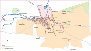
[[File:Map | [[File:Map C+.png|thumb|The former Royal Burgh,and the current [[Falkland Conservation Area]]. Based on [[Playfair and Burgess]], Map C. Roads and buildings as at around 1910. Click on the map to see a larger version.]]The '''Royal Burgh of Falkland''' received its royal charter in 1458. It was considerably smaller in extent than the [[Parish of Falkland]], and comprised most of the historic core of Falkland, but its northern boundary was the Balmblae Burn, so [[Balmblae]] was not included in the Burgh. [[Falkland Palace]] and (at times) [[Millfield]] were also outwith the Burgh. All Royal Burghs were abolished in 1975, but the name of the Royal Burgh has been preserved in the Royal Burgh of Falkland and Newton of Falkland Community Council. | ||
[[Category:Places]] | [[Category:Places]] | ||
[[Category:Articles with maps]] | [[Category:Articles with maps]] | ||
[[Category:Royal Burgh of Falkland| ]] | [[Category:Royal Burgh of Falkland| ]] | ||
Revision as of 17:08, 22 December 2021

The Royal Burgh of Falkland received its royal charter in 1458. It was considerably smaller in extent than the Parish of Falkland, and comprised most of the historic core of Falkland, but its northern boundary was the Balmblae Burn, so Balmblae was not included in the Burgh. Falkland Palace and (at times) Millfield were also outwith the Burgh. All Royal Burghs were abolished in 1975, but the name of the Royal Burgh has been preserved in the Royal Burgh of Falkland and Newton of Falkland Community Council.