Map T: Difference between revisions
Jump to navigation
Jump to search
m WikiSysop moved page Falkland Town Trail to Map T |
No edit summary |
||
| Line 1: | Line 1: | ||
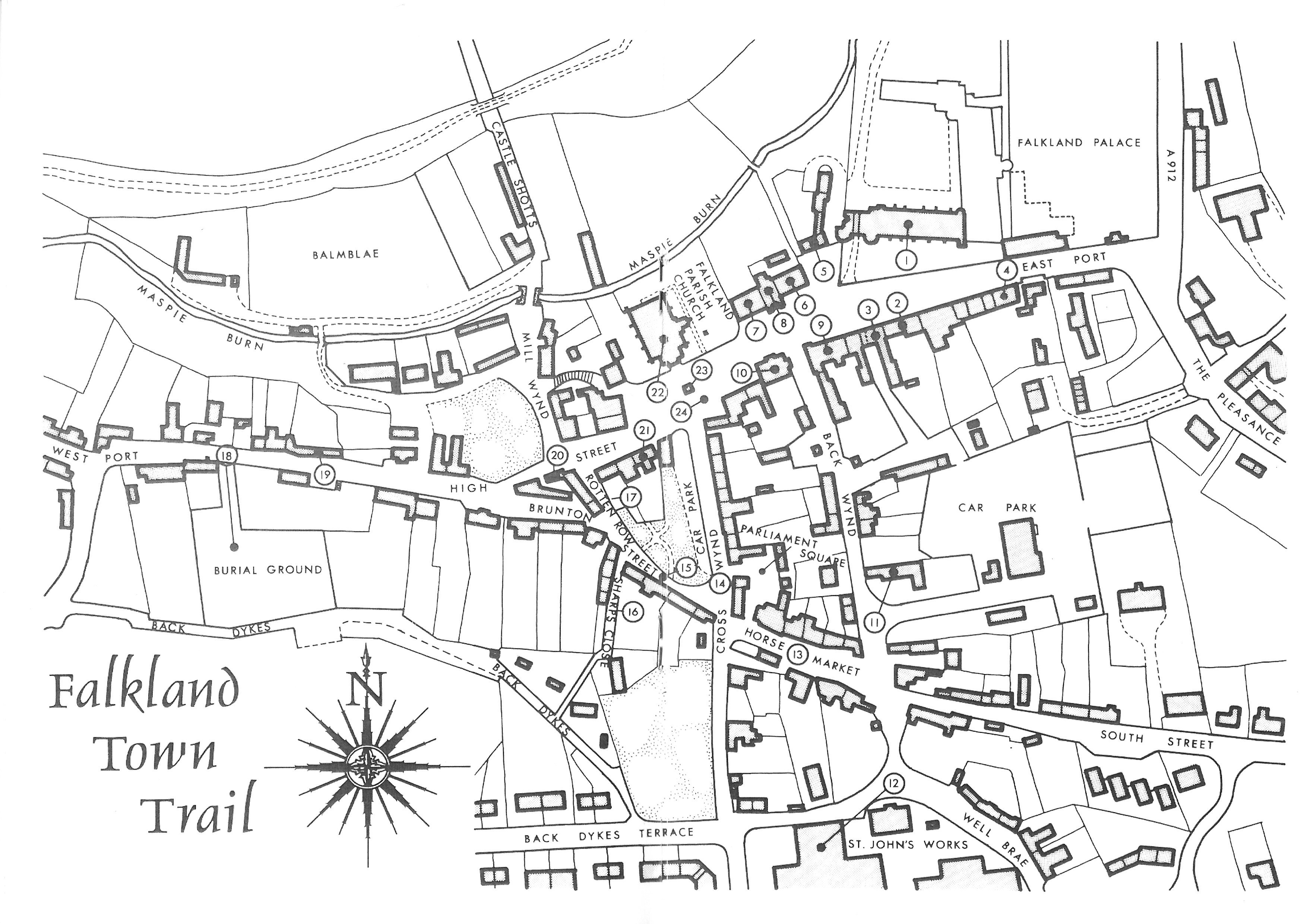
The '''Falkland Town Trail''' map is reproduced from ''[[A Falkland Guide]]'', published by The Falkland Society | The '''Falkland Town Trail''' map is reproduced from ''[[A Falkland Guide]]'', published by The Falkland Society. | ||
[[File:Falkland Guide Map.jpg|class=fullwidth]] | [[File:Falkland Guide Map.jpg|class=fullwidth]] | ||
==Explanation of numbered items== | |||
{{columns-list|2| | |||
#[[Falkland Palace]] | |||
#[[Moncrieff House]] | |||
#[[Hunting Lodge Hotel]] | |||
#"House to the left of the Post Office" ([[Tornaveen]]) | |||
#[[Key House]] | |||
#[[St Andrew's House]] | |||
#[[Saddler's House]] | |||
#Gift Shop ([[Maspie House]]) | |||
#[[The Bank]] | |||
#[[Town Hall]] | |||
#[[Youth Hostel]] | |||
#[[St John's Works]] | |||
#[[Horsemarket]] | |||
#[[Cross Wynd]] | |||
#[[Brunton Street]] | |||
#[[Sharp's Close]] | |||
#[[Rotten Row]] | |||
#[[Old Burial Ground]] | |||
#[[Weaver's Cottage]] | |||
#[[Electricity sub-station]] | |||
#[[Cameron House]] | |||
#[[Parish Church]] | |||
#[[Bruce Fountain]] | |||
#[[Mercat Cross]] | |||
}} | |||
[[Category:Maps]] | [[Category:Maps]] | ||
Latest revision as of 07:37, 4 January 2022
The Falkland Town Trail map is reproduced from A Falkland Guide, published by The Falkland Society.
Explanation of numbered items
- Falkland Palace
- Moncrieff House
- Hunting Lodge Hotel
- "House to the left of the Post Office" (Tornaveen)
- Key House
- St Andrew's House
- Saddler's House
- Gift Shop (Maspie House)
- The Bank
- Town Hall
- Youth Hostel
- St John's Works
- Horsemarket
- Cross Wynd
- Brunton Street
- Sharp's Close
- Rotten Row
- Old Burial Ground
- Weaver's Cottage
- Electricity sub-station
- Cameron House
- Parish Church
- Bruce Fountain
- Mercat Cross
