Difference between revisions of "Parish of Falkland"
Jump to navigation
Jump to search
| Line 1: | Line 1: | ||
| − | [[File:Map | + | [[File:Map 2d.PNG|thumb|The Parish of Falkland. Created by Ross Burgess for a Falkland Society lecture, and based on [[Playfair and Burgess]], Map B. Click on the map to see a larger verson.]] |
| − | The historic '''Parish of Falkland''', shown in | + | The historic '''Parish of Falkland''', shown in yellow on the map, covered a much wider area than the [[Royal Burgh of Falkland]], shown in brown, and included [[Newton of Falkland]] and [[Freuchie]]. The northern boundary of the parish was roughly the River Eden. |
| − | Officially the parish no longer exists (the current Community Council area, shown by the | + | Officially the parish no longer exists (the current Community Council area, shown by the red outline, has somewhat different boundaries) but it is still a useful way of classifying historic buildings. The [[Falkland Estate]] has had various boundaries at times; the green outline shows an early-21st century state. |
==See also== | ==See also== | ||
Revision as of 13:10, 23 January 2021

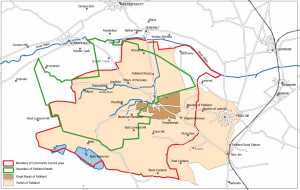
The Parish of Falkland. Created by Ross Burgess for a Falkland Society lecture, and based on Playfair and Burgess, Map B. Click on the map to see a larger verson.
The historic Parish of Falkland, shown in yellow on the map, covered a much wider area than the Royal Burgh of Falkland, shown in brown, and included Newton of Falkland and Freuchie. The northern boundary of the parish was roughly the River Eden.
Officially the parish no longer exists (the current Community Council area, shown by the red outline, has somewhat different boundaries) but it is still a useful way of classifying historic buildings. The Falkland Estate has had various boundaries at times; the green outline shows an early-21st century state.