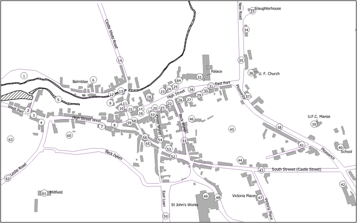
Map D
The historic centre of Falkland: Map D from Playfair and Burgess, Falkland and its people 1901–1913.
Note that this map shows buildings as existing around 1913, including some that no longer exist, and excluding many that have been built in the last hundred years.
Explanation of numbered items
(Items with an asterisk * were outside the Royal Burgh.)
- West Loan
- Viewhill House (West Port)
- West Port
- Lomond Cottage
- Mill Lade
- Balmblae *
- Bruce Buildings
- High Street West
- Police Station
- Turning Mill
- Mill Wynd
- Balmblae Burn
- Gas works
- Castle-Shots Road *
- Stag Inn
- Bryce’s store
- Co-op store
- Parish Church
- Falkland Cross
- Fountain
- Commercial Hotel
- Town Hall
- Saddlers
- Maspie House
- St Andrew’s House
- British Linen Bank
- Bruce Arms
- High Street
- Temperance Hotel (High Street)
- Old house opposite Palace
- East Port
- Falkland Palace *
- Slaughter house
- Kinnes Cottage
- New Road
- United Free Church
- Dovecot Farm
- Pleasance
- United Free Manse
- Public School
- Juniper Villa
- Temperance Hotel (Liquorstane)
- South Street
- Drill Hall
- Sugar Acre Field
- Lomondside House
- Victoria Place
- Well Brae
- St John’s Works
- East Loan
- Back Wynd
- Horsemarket
- Lomond Tavern
- Cross Wynd
- Brunton House
- Brunton Street
- Post Office (Cross Wynd)
- Colin Herd’s shop
- Reading Room
- Burying ground
- Millfield *
- Leslie Road
- Crackland Hillpark
